Thursday, March 18, 2010

Midterms and Molarities

So this week has been a little more busy than typical, due to a combination of several midterms this week and coming down with a quick cold (or some similar illness).  However, with midterms comes the great relief one feels at the end of an important exam.  Every day this week has felt like a Friday, partly because of the improved weather and partly because each test finished and school day completed brings me closer to Spring Break.

This week has also been exciting because a group of my peers and I in Geochemistry have been diligently working on preparing the crystals our teacher wants us to analyze.  Our teacher is an isotope specialist, who focuses a lot on the element Strontium, and works mainly with igneous rocks.  Subsequently we are going to run the entire digestion, column chemistry, and mass spectrometry work on crystals from Valles Caldera in the Jemez Mountains.


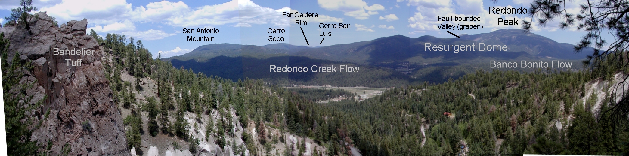
This caldera was the result of a small super-eruptive volcano, and there are calderas below the Valles (the Toledo Caldera being the main example).  I've been all around the area many times both camping and hiking, but have somehow never read anything about the geology of the area beyond the eruptions that caused the caldera systems.  It'll be interesting to learn about this place in a new light.

This geochemistry work however has shown me two very important things about myself.  I, unlike my geochemistry instructor Dr. R, am a very shaky person when it comes to handling fine instruments like micropipettes.  I have also found that I have a more than healthy respect for hydrofluoric acid and have been extremely relieved to have made it through our digestions without burning myself with any of it.  I did have the thumb of my glove disappear and I definitely burnt myself with something in the clean lab, but it was really very minor considering the concentrations of the acids we use to break down these crystals.

The irony of all this exciting work is that Dr. R had been putting it off for some time hoping to photograph the crystals with a special computer he ordered and had been waiting for.  Since we started this week, his computer naturally came today after we've dissolved them and have since started to prepare them for column chemistry to get the Sr out.

I feel truly privileged to have to opportunity to get the clean lab and analytical experience this Geochemistry project will offer.  It has really made me appreciate just how difficult preparing and analyzing rocks is on the chemical side of Geology.  I'd always known that it took thousands of man-hours to make geologic maps, measure sections of an area, and the like but I never knew putting samples through a mass spectrometer would be so involved.  I only hope that I don't mess up any of our samples, and that we can finish our runs before the write up for the class is due...

Photo Credit
Allan H. Treiman and Lunar and Planetary Institute. "Redondo Panorama 2 (Annotated)"

Monday, March 8, 2010

Paradox Basin lives up to its name for me

So, as promised I have the figure of the evaporite deposits in Paradox Basin, UT.  I've been really fascinated by these well logs, trying to figure out what sort of settings they must have formed in.  Since the key is difficult to read: green is halite, maroon red represents potash, and the gray is a gray shale.

Paradox Basin Well Logs

As you can see the pattern of deposition is always shale during stages of furthest transgression, followed by evaporite rock forming until the last of the potash dried.  Glaciation is believed to have subsided from time to time and the basin or salt flat would have recharged.  My main issue with this stratigraphy, given the near certainty that recharge must have occurred, is that the highly soluble potash top layer should have by all accounts been dissolved when the area was recharged. We also see slight layers of halite before any shale is put down which would have capped the potash and kept it in place.  If the recharge really did come from glacial melting, why does this recharge water not pick up the evaporites faster than it caps them with shale?

From the 28 cycles of halite we see in the sequence, our class determined that the rate of deposition for the evaporite and shale layers averaged around 0.1 mm/year (well within believable bounds considering modern deposition rates).  The glacial cycles also match historic trends well (not our current outlier, but previous cycles of ice ages) so the resurgence of glacial water was a dependable factor.

The deep valley/basin model some suspect formed the deposits would have provided (in my mind) enough water to dissolve the evaporites without having a deep enough water column to worry about temperature preventing uptake of evaporite sediment.  A salt pan model seems like a better candidate to me, but even that seems unlikely given the extant of the evaporite deposits, which can be pretty sizable.

I was already excited to see some of the salt tectonics of Paradox Basin in person when our class goes to visit the Colorado Plateau this summer. Now, after our teacher has introduced some features that could have placed that salt, I'm more interested to learn about current theories of what was happening in that part of the world that we now have these wonderful deposits of salt to consider.  It also makes me wonder what other curious oddities nature has hidden in remote locations of our planet, waiting to puzzle us and earn a namesake to remind us that not so long ago we thought we had most of the basics down...

Photo Credit
Hite and Liming. "Pennsylvanian Stratigraphy of Paradox Basin"